Showing posts with label extreme. Show all posts

Tuesday, 15 November 2011

Extreme Winters Caused by natural Solar Cycle?

Living not far outside of London growing up, the idea of a thick blanket of snow to play in on a winter's day was only ever a distant fantasy. You see it in the American movies all the time, and you soon learn that a 'white Christmas' doesn't really exist. When the snow fell in 2009, my inner child only had one thing in mind!


What's the significance of this? Well, it was the coldest winter on record in over 25 years, and the UK received record levels of snow. It would be easy to throw climate change to an extreme anomalous event such as this, but recent findings suggest an alternative...

Climate scientists at the UK Met Office have recently carried out a new study on the fluctuations of the sun's UV radiation. They attempted to create a link between solar activity and seasonal weather.

Satellite measurements were used and fluctuations in solar radiation were discovered to be five times as large as previously thought. They put their data into the Hadley Centre model and were able to show how these fluctuations affected regional weather.

The paper emphasises that there findings do not suggest a link to long-term global warming, rather that there is a real correlation between ultraviolet levels and meteorological variables. They show that there is actually little direct change in globally averaged temperatures as the solar activity drives cold winters in northern Europe and the United States, but mild winters are subsequently found over southern Europe and Canada.

How does it work?

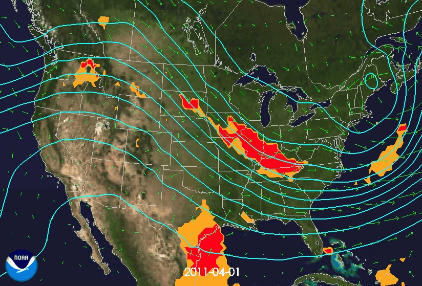
UV is absorbed in the stratosphere (the upper atmosphere) by ozone. When there is less UV to absorb, the stratosphere is relatively cooler. The Hadley centre model shows that the effects of this percolate down through the atmosphere. It is described in the paper as a 'top-down stratosphere to troposphere pathway'. As it does this, it changes wind speeds, including the jet stream that circles the globe above Europe, Russia and North America. The resultant change is a reduced air flow from the west to the east, moving colder air into the UK and northern Europe. The image below shows these changes in wind speed and pressure between Ocotber and March 2010. There is then a re-distribution of temperatures across the region, leading to the milder winters in southern Europe and Canada.

Is it quite as clear cut?

The scientists suggest that other factors may have been at play for the colder winter temperatures, including the decline of sea ice levels and El Nino. In all honesty, it could be any combination of these factors, but they suggest that the solar cycle was acting in a way to facilitate these conditions.

What's the advantages of this (other than building giant snowmen)? 

The UV measurements could be used for better forecasting. UV levels won't be able to tell us what the day-to-day weather will do, but it would enable improved forecasts for winter conditions months ahead. They would play an important role in long-term contingency planning.

In summary, the winter weather seen across the UK and Atlantic between 2009-2011 appears to back up the scientists findings. The next stage of investigation would be to look at UV measurements across a longer time-scale, to see if the patterns hold true.

Monday, 7 November 2011

165 Tornadoes in 24 Hours


The weather witnessed in Southeast US earlier this year was phenomenal. Over 600 tornadoes were recorded in April alone, breaking the previous record by several hundred. Numerous F5 tornadoes (the highest grade) with surface wind speeds greater than 200mph were also witnessed. The result was widespread and devastating destruction, including the deaths of more than 350 people. In Alabama, between 1950 and 2006, 358 people have been killed as a result of tornadoes. In the 30 day period of April 2011, 240 people were killed in Alabama.


Why so many tornadoes?

The high number of tornadoes was partly due to the Arctic Oscillation which was in a negative phase. High pressure in northern Canada, pushed the cold arctic air a long way south. On top of this, the sea surface temperatures in the Gulf of Mexico were a couple of degrees above where they should have been for the time of year.  The resulting evaporation meant warm humid air residing off the southeast coast of the US. A southerly breeze, brought this warm humid air inland, and mixed with the cold air, creating a very active weather front. In this situation, the warm air rises up above the cold air and it begins to interact with the jet stream. The jet stream was further south than it should have been and this is partly due to the La Nina phase of the ENSO oscillation. As the warm air rises and meets the cold air, almost instantaneously as a thunderstorm develops, you get the twisting motion as a result of the cold and warm air meeting with the jet stream. The twisting motion produces the tornadoes which then eventually reach the surface. The image below shows the air movements and tornado reports across April 2011.


The daily evolving 500mb heights (contours) and 850mb wind (arrows) from April 1-30, 2011.  Index: category 4 (orange) indicative of enhanced severe storm risk and category 5 (red) indicative of enhanced tornado risk. Source


A paper published in 2008 looked at whether tornado counts change location based on phase of El Nino/ Southern Oscillation. However, results found that neither frequency of tornado days nor days of violent tornados is affected systematically by the phase of ENSO for the US as a whole. Rather that ENSO only sets a ‘background stage’ for which tornado activity to occur in.
“The apparent response of organized tornado activity to ENSO phase is a nonlinear one driven by meteorological processes rather than conditions in the tropical Pacific. Neither ENSO extreme (warm nor cold phase) is related to as significant of an increase in organized tornado activity as the intermediate neutral phase is.”
Currently further research is required into the contribution of La Nina, and NOAA observational sources suggest that the tropical sea surface temperature conditions played a much larger role in what was witnessed in April 2011.


Anthropogenic Climate Change and Tornadoes

In order to assess long term climate trends, reliable long term data is required, which makes the assessment of tornadoes and climate change difficult. The US Climate Change Synthesis Report SAP 3.3 concludes that:
"The data used to examine changes in the frequency and severity of tornadoes and severe thunderstorms are inadequate to make definitive statements about actual changes."
"There were no significant changes in the high-intensity end of these distributions from the 1950s through the 1990s, although the distribution from 2000 and later may differ."

The historical record of tornado counts should always be treated with care. In some states, tornado counts have doubled in the last two decades, but this may be due to non-meteorological changes. Changes in use of equipment which result in large numbers of F0 (weakest) tornadoes being recoded which previously weren't, account for this rapid change in the recent totals (see records from Illinois below). Population growth and spotter networks also increase the amount of tornadoes witnessed and reported. Death tolls are also not necessarily that useful. In May 2004, 384 tornadoes were recorded, but only 7 deaths. In 2008, only 40 tornadoes are on record, but more than 100 people were killed. The high death toll years are often a result of just several tornadoes hitting urban centres with high populations.

a)

b)
The annual number of tornadoes per year in Illinois since 1950, regardless of strength (a) and F0 only (b). Source
"There is insufficient evidence to determine whether trends exist in.....small-scale phenomena such as tornadoes, hail, lightning and dust-storms."

Another paper on the analysis of climate change projections suggests that the number of days during which meteorological conditions are favourable for severe storms may increase during latter decades of the 21st Century, primarily due to increased instability as a result of anthropogenic forcing. However, the research projected decreases in vertical wind shear, which as a result may oppose thermodynamic destabilization. In such a case, there may not be a discernable link between tornados and climate change, which rely on increases in wind shear to form.

In summary, more research is clearly required to better understand how ENSO and its multi-year life-cycle may influence the probability of major, destructive tornado outbreaks over the US. The relation is likely to be more complicated than the simple state of the tropical Pacific sea surface temperatures. There is a large body of knowledge rapidly evolving over the possible role of large scale climate forcing caused as a result of anthropogenic impact, on tornado outbreaks. In order for this to be more successful, efforts need to me made in linking meso-scale meteorology with global-scale climate dynamics. Watch this space...

Friday, 14 October 2011

Defining Extremes - FAQs


In order to explore the subject of extreme weather and climate change, there's acouple of FAQ's that I need to clarify. If you have any further burning questions, please comment and I will follow them up in future posts.

What justifies a weather event to be regarded as extreme?

In short, a weather event can be described as extreme when it lies far beyond (on either side) of the mean and median of that weather event. The easiest way to address this question is using statistics with the aid of some simple graphs:


Any event or climate variable (such as temperature or precipitation) can be described in terms of its distribution, and the solid central curve in graph (a) could represent the the present day frequency distribution of this. Shading indicates the extreme parts of the distribution (events which occur infrequently, that are far from the mean or median value).

If there is a shift of the distribution in a future climate, there will be an increase in extreme events on one end, and a decrease at the other (a). For example, if the temperature at a certain location warms by an x amount, this will almost certainly produce an increase in the number of extreme hot days and a decrease in the number of extreme cold days. It is also important to note that there is a non-linear relationship between change in mean of the distribution and extreme changes. A small change in mean can result in a large change in the frequency of extremes (Read this paper for more info on this).

The standard deviation in a future climate may change, producing changes in extreme events at both ends of the frequency distribution (b). A change in variance of a distribution has a larger effect on the frequency of extremes than a change in the mean (but has to be more than one standard deviation from the mean in order to be extreme and hold true). For example a 1 degree Celsius change in the standard deviation of the distribution will have a larger impact on the extremes than a 1 degree change in the mean of the distribution. A good paper explaining this further can be found here.

To complicate things further, you can end up with something such as that in graph (c), whereby both the mean and variance change, altering the occurrence of extremes in several ways. An example of this would be precipitation, which is not normally distributed, and a change in mean also causes a change in variance. 

Are the effects of extreme weather always negative?

No, although the negatives tend to far outweigh the positives. Despite extreme weather events often being associated with negative effects on society and the natural environment, through events such as storms, droughts, extreme colds and floods, there are also some advantages. For example, energy production and reduction in energy costs (e.g. from power generated through wind turbines in windier conditions), surplus of water in some areas of Australia (following cyclones), which feeds longer term storage. Arctic, Antarctic and Siberia may experience more plant growth and greater biodiversity with a warming climate. Also, changes in precipitation patterns may result in longer growing seasons in some areas. However, with each of these positives come many negatives, including loss of power, damage to infrastructure, reduction of growing seasons, loss of biodiversity... the list goes on.

As a short and sweet introductory reading to this subject, I can suggest this free-to-access paper which gives a general overview of trends in extreme weather and climate events. It also touches upon the effects of such changes on the human and natural environment.